SAN DIEGO (KGTV) — The flooding on Jan. 22, 2024, has been described as historic. That day, meteorologist Megan Parry helped guide viewers through the aftermath, providing updates on the ever-changing conditions.
She follows through by explaining that with climate change, events like this are becoming more common.
This storm brought catastrophic flooding to parts of San Diego. It was particularly intense over southern San Diego, as seen in a drone video, and in Mountain View, another hard-hit neighborhood.
This is what the rain looked like on the radar that morning, with the red indicating pouring rain.
And from the satellite view, an impressive moisture plume took aim directly at Southern California.
So why did we get so much rain?
Well, this storm was fueled by an unusually strong Pacific jet stream that tapered into an atmospheric river. Storms can be measured in several ways, including how much rain fell and how fast that rain fell.
Both metrics were historic on Jan. 22.
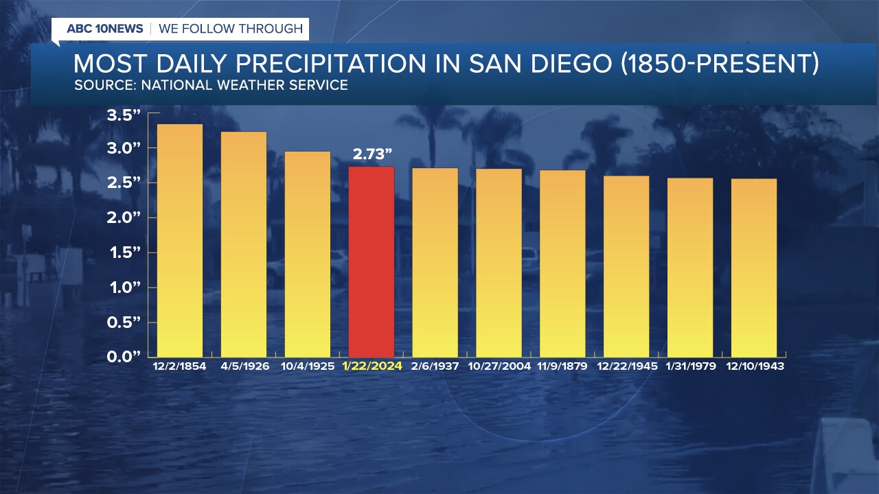
Downtown saw 2.73 inches of rain, the most daily rainfall since 1860 and the fourth wettest day of all time.

The speed at which the rain fell was also historic. For perspective, a more typical rainfall would be a quarter inch per hour; rain fell at a rate of 1.5 inches per hour that day.
Multiple rain gauges recorded 2-2.5 inches of rain in one hour on Jan. 22. In just three hours, everyone in the metro area had 2-4 inches of rain.
That makes this a 1,000-year weather event.
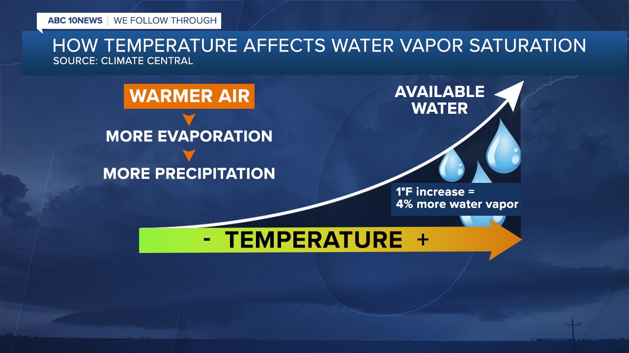
Heavy rain events like these are becoming more likely in a warming world. The relationship between air temperature and water vapor is governed by the laws of thermodynamics, which say that for every one-degree Fahrenheit increase in temperature, the atmosphere can hold 4% more moisture.

That might not seem like much, but it has noticeable effects, according to Climate Central, an independent group of scientists and communicators. They analyzed the average annual temperature trend across the U.S. They found that since 1970, the U.S. average temperature has warmed by 2.6 degrees Fahrenheit, meaning the atmosphere can now hold about 10% more moisture.
The top 10 hottest years have also occurred in the last ten years.
This extra moisture in the atmosphere is contributing to heavier downpours. Hourly rainfall intensity has increased across every U.S. region, with the largest spikes in the central and southwest regions.
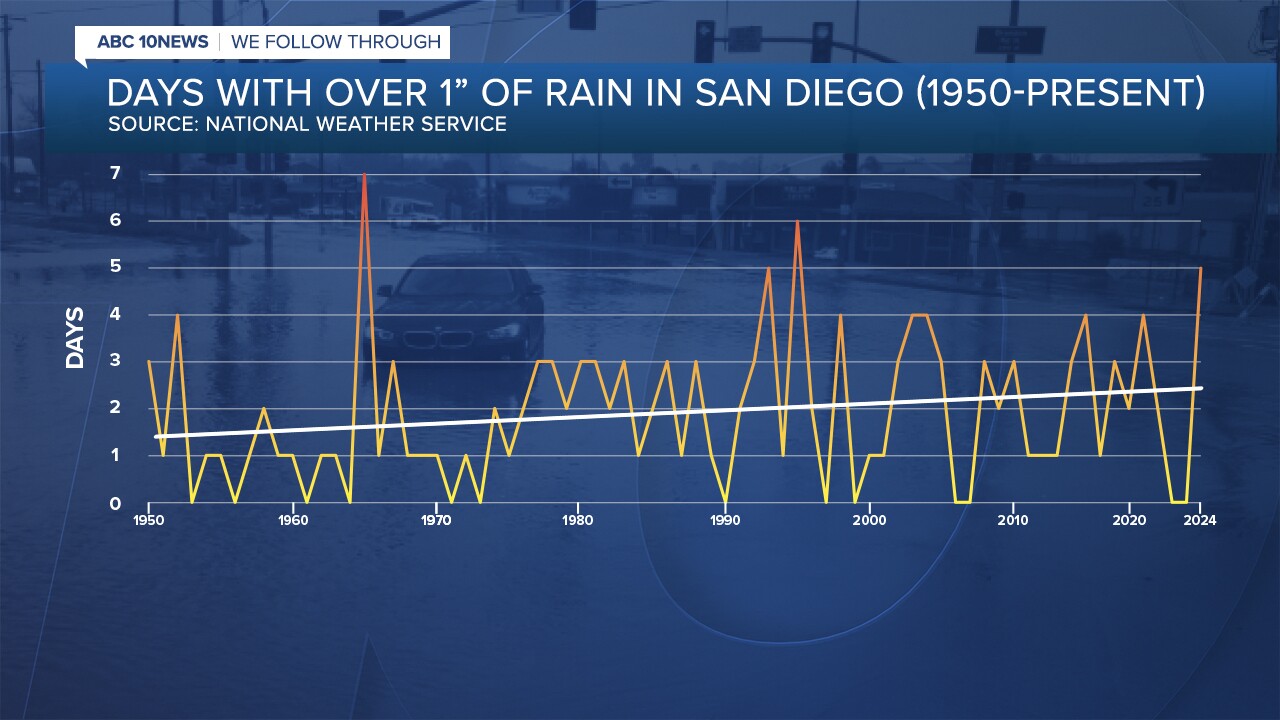
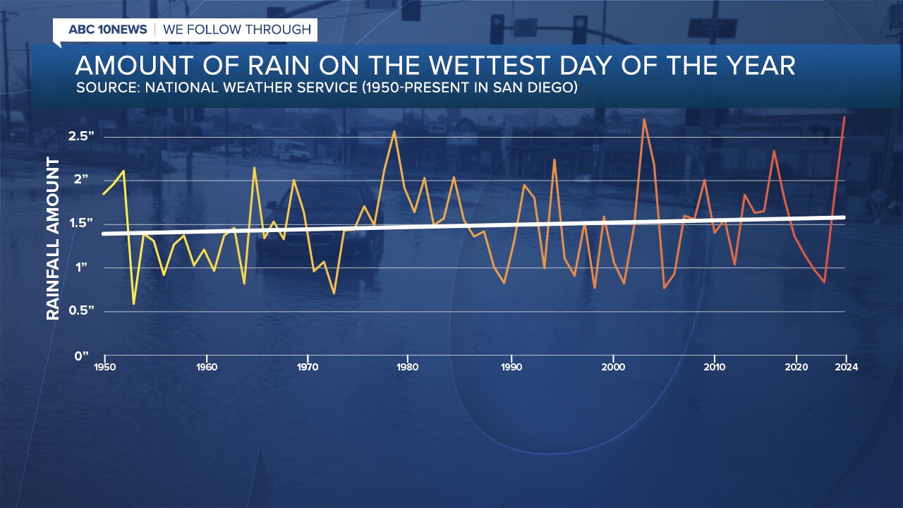
The U.S. has seen an average of over 20% more heavy rain days since 1950. Meanwhile, San Diego, based on records kept at Lindbergh Field, is seeing an average of one more day a year of 1 inch of rain or more. Our wettest days are also trending wetter, averaging about half an inch more.


Climate change is essentially supercharging the water cycle, causing more extreme rainfall—and, with it, a higher risk of flooding.
The Intergovernmental Panel on Climate Change reports with high confidence that the frequency and intensity of heavy rainfall events have increased globally since the 1950s, largely due to human-caused climate change.
But climate change isn't just about more rain—it's about more extremes.
We’re not necessarily seeing more rain annually, but when storms hit, they produce much more rain in shorter periods. And it’s not just floods—we’re also seeing more intense droughts.


